An essential part of any serious Bug Out Bag (BOB), Get Home Bag (GHB), survival pack, or outdoorsman’s rucksack is a magnetic compass. Not a smartphone compass app, but a real, no battery needed compass.
A magnetic compass will always work because of Earth’s magnetic field.
There are two main types of magnetic compass: a lensatic compass and the baseplate compass (also commonly known as an orienteering compass.)
Baseplate compasses work well with maps, but certainly can be used without a map as well.
We’re going to review the best options for baseplate compasses, because that’s the type we’d recommend.
Compass, Map, and Land Navigation Terms Primer
We’re going to present a variety of compass options.
To understand the benefit of some of these compass features, it would be good to quickly review some of the key terms involved with magnetic compasses and land navigation. Much of this information is derived from the US Army’s field manual for Map Reading and Land Navigation[1].
For those without military experience, it should be known that the military has driven the need for accurate and complete maps since the beginning of human history.
We’ll start with map terminology. A map is a graphic representation of a portion of the earth’s surface drawn to scale, as seen from above.
Maps intended for navigation have a rectangular grid superimposed on top for ease of use. These so called grid squares can be defined in a variety of ways. The US military has standardized on the Universal Transverse Mercator (UTM) grid for many, many years.
UTM is gaining popularity in the GPS device world as well, because it is easier to comprehend than Latitude and Longitude.
For the polar regions of the Earth (South pole, North pole) an alternative grid format is used – the Universal Polar Stereographic (UPS) grid. Polar navigation is probably the exception for most of our readers, so we won’t focus on it further.
The grid squares are of fixed size, representing some distance. If you know the grid size, you can tell how far (or close) another location is on the map.
Map Scale is the ratio or fraction between the distance on a map and the corresponding distance on the surface of the earth. Maps with scale 1:50,000 are preferred for most land navigation. For example, the scale note 1:50,000 indicates that one unit of measure on the map equals 50,000 units of the same measure on the ground. This method of representing the scale is known as the Representative Fraction (RF).
A topographic map is typically used for land navigation. Unlike the road map you may be familiar with, this type of map uses contour lines to represent terrain features such as hills, ridges, valleys, and other changes in elevation. These are important considerations when you are going off the established roads and traveling by foot.
Further, these maps use colors to designate features – blue for water (lakes, swamps, rivers, etc.), green for vegetation and forests, etc.
Direction is an important concept in land navigation. Directions are expressed as units of angular measure.
Degrees are most common unit of measure for direction. There are 360 degrees (º) with subdivisions of minutes (‘) and seconds (“). 1 degree = 60 minutes, and 1 minute = 60 seconds.
Another popular unit of direction in the military is the mil. The mil expresses the size of an angle formed when a circle is divided into 6,400 equally sized angles.
Both degrees and mils represent the same concept. A circle equals 6400 mils divided by 360 degrees, or 17.78 mils per degree. To convert degrees to mils, multiply degrees by 17.78.
Some foreign maps may use grads as their unit of direction. There are 400 grads in a full circle.
To use direction, we must have an agreed to starting point, or base line.
Everyone is familiar with the concept of North. But there are in fact three strict interpretations of where north is.
True north is defined as a line from any point on the earth’s surface to
the north pole. On a map or compass it is usually represented via a star.
By the way, the North Star – which is visible at night from just about anywhere in the northern hemisphere is less than 1 degree off true north and does not move from its place because the axis of the earth is pointed toward it. Hence the name.
Magnetic north is the direction to the north magnetic pole, as indicated by the north-seeking needle of a magnetic instrument. The magnetic north is usually symbolized by a line ending with half of an arrowhead.
Lastly, grid north is the north that is established by using the vertical grid lines
on the map. Usually designated as GN on the map.
Magnetic north is what we’ll use most with a magnetic compass.
An azimuth is a horizontal angle, measured in a clockwise manner from a north base line, expressing direction.
Back azimuth is the opposite direction of an azimuth. Think of the “about face” – a turn to face the opposite direction. Because it is the opposite direction of an azimuth, you can obtain a back azimuth from an azimuth by simply adding 180 degrees if the azimuth is 180 degrees or less; or subtracting 180 degrees if the azimuth is 180 degrees or more.
Azimuth is also commonly called a bearing.
To determine the direction of travel to reach another point on the map, we’d figure out the grid azimuth between the starting point and ending point.
To obtain a grid azimuth a protractor is used. This clear plastic measuring device is meant to be laid over the map such that you can quickly and easily generate a grid azimuth as needed.
Declination is the angular difference between any two norths. If you have a map and a
compass, the declination of most interest to you will be between magnetic and grid north.
The first step to using a map correctly is orienting the map.
Maps for navigation will typically include a declination diagram which indicates the angular relationships of true north, grid north, and magnetic north.
This is necessary because your magnetic compass has utterly no way to know “grid north”. Based on the earth’s magnetism it can only directly measure magnetic north. The magnetic compass measures magnetic azimuths. You use declination adjustments to ensure you can correctly orient your direction to the maps.
Resection is the method of locating one’s position on a map by determining the grid azimuth to at least two well-defined locations that can be pinpointed on the map. This might be things such as tall man made structures that can be located both visually and appear on the map.
But a distinct geographical feature such as a hilltop might be used as well.
And lastly, an important part of land navigation with a map and compass is keeping an accurate pace count. The compass will tell you what direction to head, but most times you’ve got to measure distance on your own.
Features of the Best Baseplate Compass
Things to look for:
- Magnifying Lens
- Jewel Bearing
- Liquid filled
- Global
- Luminous bezel and markings for nighttime viewing
- Adjustable declination correction – REI guide on how to set declination.
- Mirror
- Clinometer
– vs Balanced for northern hemisphere
Suunto A-10 Recreational Field Compass

- Recreational Compass: Minimalistic and straightforward, the A-10 compass is the ideal hiking and orienteering compass that is fast and simple to use; Balanced for northern hemisphere use with inch/cm scales and a fixed declination
- Baseplate Compass: Ideal for navigating with a map and compass, the A 10 is compact and features a high grade steel needle with jewel bearing and a liquid filled capsule for stable operation
- Stay On Course: Made in Finland, Suunto mechanical compasses help you safely and accurately navigate the great outdoors; Great for Alpine skiing, hiking, trekking, mountain biking, trail running and more
- Pioneering Exploration: Combining advanced engineering and thoughtful design with ultra durable materials, our adventure ready compasses are fast, stable, and simple to use; No batteries required
- Authentic Heritage: Founded in 1936, Suunto brings over 80 years of high quality heritage craftsmanship, relentless accuracy, and pioneering innovation to our watches, compasses, and dive products

The Suunto A-10 (Buy on Amazon) is Suunto’s entry level hiking and orienteering compass. It is fast, simple and accurate.
Baseplate compasses are quick to learn and ideal for navigating with a map and compass.
This model is marked with Imperial scales (inches and miles).
It includes a lanyard as well.
This is the best cheap, but accurate compass option from Suunto.
Suunto A-30 NH Metric Compass
- Hiking Compass: Compact and accurate compass that features a high grade steel needle with jewel bearing; The baseplate compass is balanced for northern hemisphere use with Metric scales and a fixed declination
- Precise And Practical: Great for hiking and orienteering, the A-30 Compass has luminescent markings for low light conditions and a magnifying lens on a transparent baseplate for easy use with map
- Stay On Course: Made in Finland, Suunto mechanical compasses help you safely and accurately navigate the great outdoors; Great for Alpine skiing, hiking, trekking, mountain biking, trail running and more
- Pioneering Exploration: Combining advanced engineering and thoughtful design with ultra durable materials, our adventure ready compasses are fast, stable, and simple to use; No batteries required
- Authentic Heritage: Founded in 1936, Suunto brings over 80 years of high quality heritage craftsmanship, relentless accuracy, and pioneering innovation to our watches, compasses, and dive products

Step up to the and you also get luminescent markings so it’s easier to operate in low light, and a magnifying lens on the transparent baseplate.
This makes it easier to use with a map – especially for those with aged eyes. But to be honest in any low-light condition magnification makes it much easier to see small map details.
The magnifier and can double as a fire starting implement in extreme circumstances.
The Suunto A-30 is marked with metric scales – centimeters and kilometers.
And the “NH” in the name? It’s balanced for the Northern Hemisphere. So don’t get this if you need a global compass balanced for both the northern and southern hemispheres.
Includes a detachable lanyard, and has the Suunto limited lifetime warranty.
Suunto M-3 G Compass
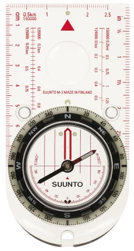
- Adventure Compass: The M-3 compass is a premium quality precision compass for convenient direction taking in demanding conditions; The M-3 is a hardy baseplate compass ready for the challenge
- Precise And Reliable: The M-3 NH features a needle blanced for northern hemisphere, adjustable declination, scales in metric and imperial, luminescent markings for low light use, and a magnifying lens on a transparent baseplate for easy use with maps
- Stay On Course: Made in Finland, Suunto mechanical compasses help you safely and accurately navigate the great outdoors; Great for Alpine skiing, hiking, trekking, mountain biking, trail running and more
- Pioneering Exploration: Combining advanced engineering and thoughtful design with ultra durable materials, our adventure ready compasses are fast, stable, and simple to use; No batteries required
- Authentic Heritage: Founded in 1936, Suunto brings over 80 years of high quality heritage craftsmanship, relentless accuracy, and pioneering innovation to our watches, compasses, and dive products

This is considered a premium compass, because it’s got some real important features.
The M-3 G Compass (Buy on Amazon) is globally balanced – that’s what the G stands for in the name.
It’s got the baseplate with magnifying lens. Not only that, it also has the low-light luminescent markings.
What’s more – it is marked up in both metric and imperial UTM scales. If you never know what sort of map you are going to end up working with, this is your best option.
This model also has adjustable declination.
And lastly, this compass includes a liquid filled clinometer with 2 degrees accuracy.
A clinometer is used for measuring angles of slope (or tilt) and elevation.
Why do you need that on a compass? It can be used to estimate a slope’s angle of inclination from which changes in elevation may be calculated – this is often important when navigating backcountry.
Suunto MC-2 Baseplate Compass

- Metric UTM scales and inch ruler
- Adjustable declination correction
- Mirror for sighting bearings and signaling
- Clinometer
- Luminescent markings for working in low light
The Suunto MC-2 Compass (Buy on Amazon) is our premium baseplate compass pick.
It’s got all the premium features of the other models, and more:
- Fast globally balanced needle with jewel bearing
- 20 degrees tilt margin for easier readings
- Adjustable declination correction
- Liquid filled capsule for stable operation
- Mirror for sighting bearings and signaling
- Sighting hole and notch for accurate bearings
- Clinometer – liquid filled
- Luminescent markings for working in low light – bezel, orienting markings, and direction of travel
- Metric UTM scales and inch ruler
- Baseplate with magnifying lens
- Detachable snap-lock lanyard with wristlock. Easy to detach for working with the map
- Suunto limited lifetime warranty – made in Finland
But perhaps most importantly – it’s a mirror compass.
Why a mirrored compass?
First, it let’s you sight a direction or an object with the compass capsule visible at the same time (by having the mirror angled at 45 degrees.)
Secondly, you can use it as a signaling mirror
And third, a mirror can be helpful when inspecting for ticks or other parasitic insect bites.)
This model also has just about every other feature you would want on a compass.
Alternatives to the Baseplate Compass
If you served in the US armed forces and were trained on land nav; you’ll recognize this item.
This is the Cammenga Tritium Lensatic Compass (Buy on Amazon).
This is a robust item manufactured to military accuracy standards.
It has glow-in-the-dark markings which use Tritium.


Baseplate Compass – In Summary
We recommend every serious survival pack or go bag have a good, old fashioned magnetic compass.
We recommend baseplate (or orienteering) compasses because they can be used with a map, or without.
Some models have additional features, such as a mirrors, that can double as important survival items.
But, a military style compass like the Cammenga models can be a useful item as well.
Dead reckoning land nav is something you may have to do on the ruck march – and it’s good survival gear in any disaster situation.
References
[1] US Army FIELD MANUAL No. 3-25.26 – MAP READING AND LAND NAVIGATION

The appearance of U.S. Department of Defense (DoD) visual information does not imply or constitute DoD endorsement.
Last update on 2026-07-14 / Affiliate links / Images from Amazon Product Advertising API